Search Router
This element creates a configurable search formular with result output. At this time generic SQL search is supported, with more to come (WFS, Solr, …).
Configuration
The SearchRouter needs access to the database where the search tables are. You have to define a new database configuration to be able to connect with the geo database. Read more about this at database.
Example for a PostgreSQL database on localhost, called gisdb:
Content in config.yml:
doctrine:
    dbal:
        default_connection: default
        connections:
            default:
                [...]
            gisdb:
                driver:   "%gisdb_database_driver%"
                host:     "%gisdb_database_host%"
                port:     "%gisdb_database_port%"
                dbname:   "%gisdb_database_name%"
                path:     "%gisdb_database_path%"
                user:     "%gisdb_database_user%"
                password: "%gisdb_database_password%"
                persistent: true
                charset:  UTF8
                logging: "%kernel.debug%"
                profiling: "%kernel.debug%"
Content in parameters.yml
parameters:
    [...]
    gisdb_database_driver:   pdo_pgsql
    gisdb_database_host:     localhost
    gisdb_database_port:     5432
    gisdb_database_name:     gisdb
    gisdb_database_path:     null
    gisdb_database_user:     reader
    gisdb_database_password: mypassword
- Title: Title of the element. The title will be listed in “Layouts” and allows to distinguish between different buttons. It will be indicated if “Show label” is activated.
- Target: Id of Map element to query.
- Dialog: Render inside a dialog or not.
- Timeout factor: Timeout factor (multiplied with autcomplete delay) to prevent autocomplete right after a search has been started.
- Width: Width of the dialog (only for dialog, not sidepane)
- Height: Height of the dialog (only for dialog, not sidepane)
- Routes: Collection of search routes.
- Title: Search Title (appears, when a search is added to Routes by using +)
- Configuration: Field to configure the search (ppears, when a search is added to Routes by using +)
You can define Searches (Routes) with the + Button. Each Search has a title which will show up in the search form in a selectbox where you can choose the search you want to use, and a configuration. The definition of the search is done in YAML syntax in the textarea configuration. Here you define the database connection, the Search tables/views, the design of the form and of the result table.
The element may be integrated into the sidepane or as a button into the toolbar. To configure a button visit the documentation at Button
Example
The following example uses the german geographical names data in 1:250.000 from the Bundesamt für Kartographie und Geodäsie. The data was extracted to gn250_p table in the gisdb database (see parameters.yml above) and can be used for the search. The data has some specific columns:
- id: the id of the dataset
- name: the name of the dataset
- kreis: the administrative county (not for every dataset)
- oba_wert: the type of data (e.g. station, museum, etc.)
Example of a route-configuration in the configuration area:
class: Mapbender\CoreBundle\Component\SQLSearchEngine
class_options:
  connection: gisdb
  relation: gn250_p
  attributes:
    - id
    - name
    - kreis
    - oba_wert
  geometry_attribute: geom
form:
  name:
    type: text
    options:
      required: true
    compare: ilike
results:
  view: table
  count: true
  headers:
    id: ID
    name: Name
    kreis: Landkreis
    oba_wert: Art
  callback:
    event: click
    options:
      buffer: 10
      minScale: null
      maxScale: null
Comparison Mode
For every field a comparison mode can be set, which should be used by the engine when the query is send. The SQL search engine has the following modes:
- exact: exact comparison (key = val)
- iexact: comparison ignoring cases (case-insensitive)
- like: Standard, both-side ‘like’
- like-left: left-hand ‘like’
- like-right: right-hand ‘like’
- ilike: both-side ‘like’, (case-insensitive - *searchstring*)
- ilike-left: left-side ‘like’ (case-insensitive - *searchstring)
- ilike-right: right-side ‘like’ (case-insensitive - searchstring*)
Styling the Results
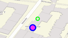
By default the results are shown in the default-OpenLayers Style, orange for hits and blue fo selected objects. The OpenLayer default Styling looks like this:
You can overwride this by handing over a styleMap-Configuration, which could look like this:
results:
    [...]
    styleMap:
        default:
            strokeColor: '#00ff00'  # Umrandungsfarbe
            strokeOpacity: 1        # 1 - opak (keine Transparenz)
            strokeWidth: 3          # Umrandingsbreite
            fillColor: '#f0f0f0'    # Füllfarbe
            fillOpacity: 0          # Opazität Füllung, voll transparent, daher keine Füllung
            pointRadius: 6          # Größe des Punktsymbols
        select:
            strokeColor: '#0000ff'
            strokeOpacity: 1
            strokeWidth: 4
            fillColor: '#ff00ff'
            fillOpacity: 0.8
            pointRadius: 10
        temporary:
           strokeColor: '#0000ff'
           fillColor: '#0000ff'
           fillOpacity: 1
Three different styles are configured:
- default: The standard-style for all results
- select: The style used if a result is clicked.
- temporary: The styles used if you hover with the mouse-pointer over a result.der Tabelle bewegt.
This will not draw the point-symbol interiors, since the transparency is set to Zero (fillOpacity: 0). Only their outlines will be drawn in green. The selected features will be drawn here in with a purple fill and an opacity of 0.8. The stroke-Color is a blue line. The temporary symbols on mouse-hover are opaque blue points. The following screenshot shows this design:
The default settings override the OpenLayers-Default Settings, so you only have to state the things you want to overwride. If you state nothing, the default OpenLayer style will be used.
The select-style works the same way. Any statement you make woll overwrite the settings of the final default style.
Note, that the hexadeximal color values have to be stated in quotation marks, because the #-Symbol would be interpreted as a comment instead.
Configuration Examples
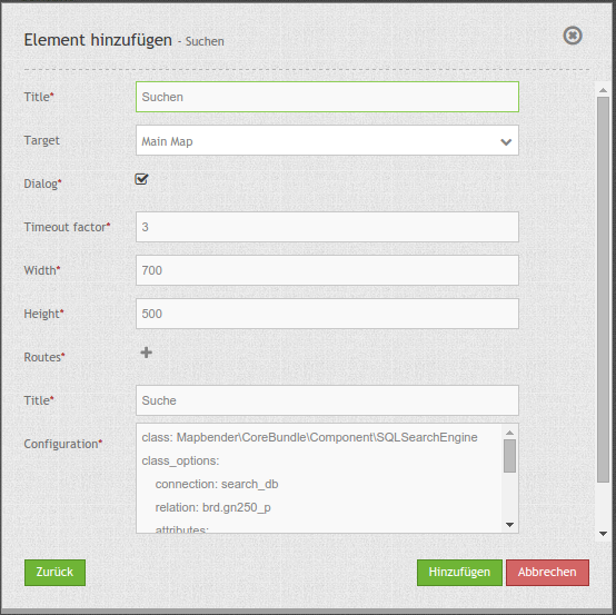
In this example a search was configured for the Mapbender user and added into the sidepane, usable under the + in Layouts.

The confguration dialouge for this example looks like this:
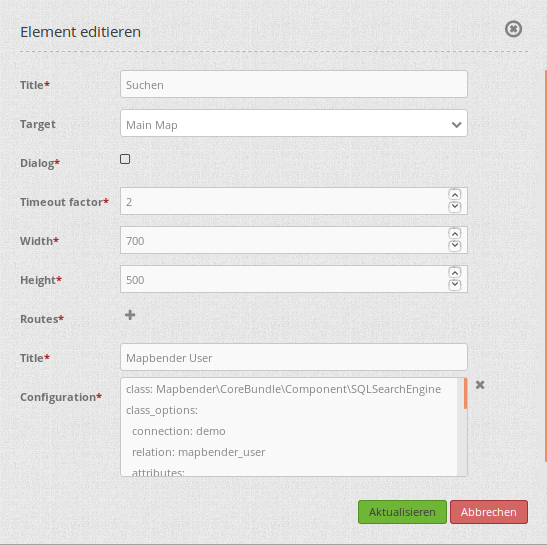
The element title (Title) is Search. It is againg diplayed as a title in the sidepane. The checkbox is unchecked, because the element is is implemented into the sidepane and not as a button. The Timeout factor is set to 2. The fields Width and Height are filled, but they wont be used in this application, because the element is configured in the sidepane. It is implemented via the + -Symbol and Routes into the search, called (Title) Mapbender User. The yaml-Configuration of the Element is written in Configuration. In Completion it reads:
class: Mapbender\CoreBundle\Component\SQLSearchEngine
class_options:
  connection: demo        # die Datenbank, auf die das Element zugreift
  relation: mapbender_user      # die Tabelle, auf die das Element zugreift
  attributes:          # entspricht den Tabellenspalten in der Datenbank, die angesprochen werden sollen
    - gid
    - orga
    - town
    - usertype
  geometry_attribute: the_geom      # Definition der Geometrie Spalte
form:            # ab hier beginnt die Konfiguration des Formulars
  orga:            # Feld für die Suche nach dem Namen des Mapbender Users
    type: text
    options:
      required: false        # kein Pflichtfeld
      label: 'Mapbender User'      # Überschrift über dem Feld
      attr:          # zusätzlich definierbare Attribute
        data-autocomplete: 'on'      # automatische Vervollständigung des eingetippten Suchbegriffs
        data-autocomplete-distinct: 'on'
    compare: ilike        # Vergleichsmodus
  town:            # Feld für die Suche nach der Stadt
    type: text
    options:
      required: false        # kein Pflichtfeld
      label: Stadt        # Überschrift über dem Feld
      attr:
        data-autocomplete: 'on'
        data-autocomplete-distinct: 'on'
    compare: ilike
  usertype:          # Feld für die Suche nach dem Nutzertyp
    type: choice        # Feld mit Auswahlmöglichkeiten als Dropdown
    options:
      empty_value: 'Bitte auswählen...'    # Text, der angezeigt wird, bevor etwas ausgewählt wurde
      choices:          # die Auswahlmöglichkeiten; werden wie folgt angegeben: "Eintrag in der Spalte der Datenbank": "Angezeiger Name in der Dropdown-Liste"
        1: Company
        2: Administration
        3: University
        4: User
      required: false        # kein Pflichtfeld
      label: Nutzertyp        # Überschrift über dem Feld
    compare: exact        # Vergleichsmodus
results:          # Konfiguration der Ergebnisanzeige
  view: table          # Tabelle ausgeben
  count: true          # Anzahl der Ergebnisse anzeigen
  headers:          # Titel der Spalte; werden wie folgt angegeben: Spaltenname in der Datenbank: Bezeichnung der Spalte in der Suchausgabe der Anwendung
    gid: ID
    orga: 'Mapbender User'
    town: Stadt
  callback:
    event: click        # bei Klicken wird das Element selektiert
    options:
      buffer: 10
      minScale: null
      maxScale: 10000
  styleMap:          # Styling der Punkte in der Karte
    default:          # Styling aller angezeigten Punkte
      strokeColor: '#003366'
      strokeOpacity: 1
      fillColor: '#3366cc'
      fillOpacity: 0.5
    select:          # Styling des selektierten Objekts
      strokeColor: '#330000'
      strokeOpacity: 1
      fillColor: '#800000'
      fillOpacity: 0.5
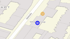
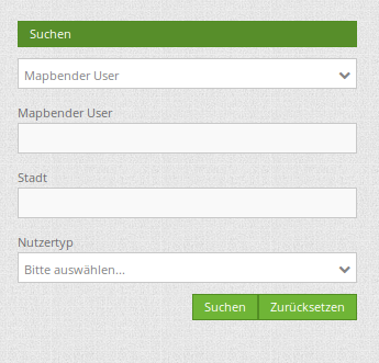
With this configuration the search in the application looks like this:
This picture illustrates which consequences the configurations in the yaml-definition have for the search formula:
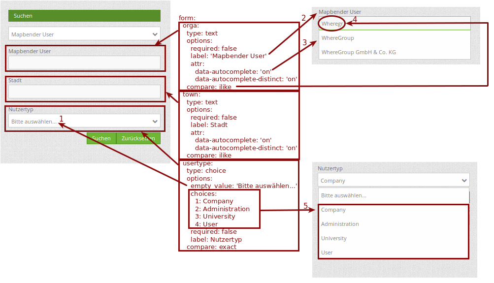
Displayed is the excerpt of the yaml-definition configureing the formula. Columns orga, town and usertype are used in the formula and implemented as the fields Mapebender User, Town and Usertype. Mapbender User and Town are type text, Usertype can be of various types. The text that should be displayed, if nothing is selected yet, is here “Please select…” (Nr. 1 – empty_value: ‚Please select…‘). The title above these fields is set with label (Nr. 2). The attribute data-autocomplete: ‚on‘ results in a dropdown menu with recommendations from the database (Nr. 3). Because compare: ilike is enabled it is not necessary to write the exact word. The search will find results that are only similar to the written term (Nr. 4 – Wheregr (the g is lowercase, nevertheless WhereGroup with uppercase G was found). The fieldtype choice is variable, possibilities are defined in choices (Nr. 5). The table contains the possibilities as numbers (1, 2, 3, 4). In this example every number represents a text, which should be displayed in the dropdown menu.
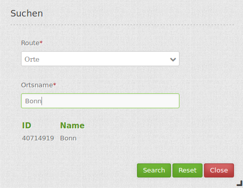
A complete search for the Mapbender User WhereGroup, in the Town Bonn, of the Usertype Company and the found results will look like this:
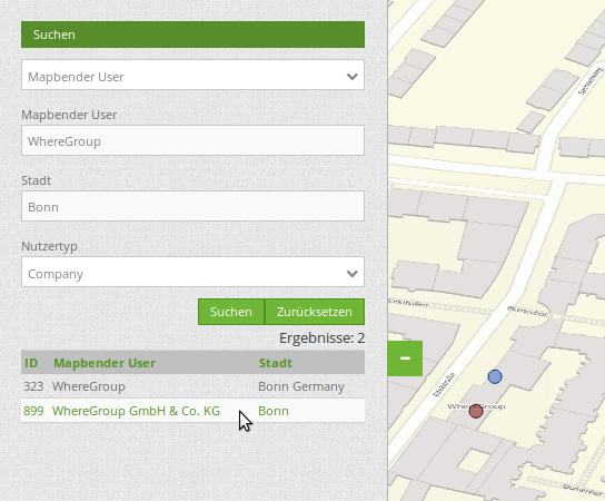
This picture illustrates the consequences our configuration of the yaml-defnition had on the display of the results.
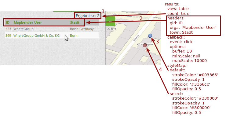
Here only the configuration of the results is shown. The number of results is shown because count: true (Nr. 1) is enabled. The titles of the columns are defined in headeers (Nr. 2). Here the name of the column is mentioned first, to define which results are referenced. After the colon we set the title which will be displayed in the application. In the block styleMap the points are styled. The block default (Nr. 3) references all points, and the block select (Nr. 4) only selected points.
Because none of these fields are mandatory the search will work wih only on field.
Additional configuration examples
Example with autocomplete and individualized display of results:
Create or Replace view brd.qry_gn250_p_ortslage as Select gid, name, gemeinde, bundesland, oba, ewz_ger, hoehe_ger ,geom from brd.gn250_p where oba = 'AX_Ortslage' order by name;
class: Mapbender\CoreBundle\Component\SQLSearchEngine
class_options:
    connection: search_db
    relation: brd.qry_gn250_p_ortslage
    attributes:
  - gid
  - name
  - gemeinde
  - bundesland
  - ewz_ger
  - hoehe_ger
    geometry_attribute: geom
form:
    name:
  type: text
  options:
      required: false
      label: Name
      attr:
          data-autocomplete: on
  compare: ilike
    gemeinde:
  type: text
  options:
      required: false
  compare: ilike
results:
    view: table
    count: true
    headers:
  name: Name
  gemeinde: Gemeinde
  bundesland: Bundesland
  ewz_ger: Einwohner
  hoehe_ger: Höhe
    callback:
  event: click
  options:
      buffer: 1000
      minScale: null
      maxScale: null
    styleMap:
  default:
      strokeColor: '#00ff00'
      strokeOpacity: 1
      fillOpacity: 0
  select:
      strokeColor: '#ff0000'
      fillColor: '#ff0000'
      fillOpacity: 0.8
  temporary:
      strokeColor: '#0000ff'
      fillColor: '#0000ff'
      fillOpacity: 1
Example with selection box:
Create or Replace view brd.qry_gn250_p as Select gid, name, gemeinde, bundesland, oba, geom from brd.gn250_p where oba = 'AX_Ortslage' OR oba = 'AX_Wasserlauf' order by name;
class: Mapbender\CoreBundle\Component\SQLSearchEngine
class_options:
    connection: search_db
    relation: brd.qry_gn250_p_ortslage
    attributes:
  - gid
  - name
  - gemeinde
  - bundesland
  - oba
    geometry_attribute: geom
form:
    oba:
  type: choice
  options:
      empty_value: 'Bitte wählen...'
      choices:
          AX_Ortslage: Ort
          AX_Wasserlauf: 'Gewässer'
    name:
  type: text
  options:
      required: false
      label: Name
      attr:
          data-autocomplete: on
  compare: ilike
    gemeinde:
  type: text
  options:
      required: false
  compare: ilike
results:
    view: table
    count: true
    headers:
  name: Name
  gemeinde: Gemeinde
  bundesland: Bundesland
    callback:
  event: click
  options:
      buffer: 1000
      minScale: null
      maxScale: null
YAML-Definition
In the mapbender.yml file:
target: map # ID des Kartenelements
asDialog: true # true, Erebniswiedergabe in einem Dialogfeld
timeoutFactor:  3 # Timeout-Faktor (multipliziert mit autcomplete Verzögerung) um die Autovervollständigung zu verhindern, nachdem eine Suche gestartet wurde
height: 500 # Höhe des Dialogs
width: 700 # Breite des Dialogs
routes:    # Sammlung von Suchrouten
    demo_polygon:  # für Maschinen lesbarer Name
   class: Mapbender\CoreBundle\Component\SQLSearchEngine  #  Suchmaschine, die verwendet werden soll
   class_options:  # Diese werden an die Suchmaschine weitergegeben
       connection: digi_suche    # search_db  # DBAL Verbindungsname, der benutzt werden soll, benutzen sie ~ für default
       relation: polygons # Verbindungsauswahl, Unterabfragen können verwendet werden
       attributes:
           - gid  # Liste von Spalten auswählen, expressions are possible
           - name
           - type
       geometry_attribute: geom  # Name der Geometriesplate, die genutzt werden soll. Achtung: Projektion muss mit Projektion des map-Elements übereinstimmen
   form:  # Einstellungen für das Suchformular
       name:  # Feldname, Spaltenname der genutzt werden soll
           type: text  # Eingabefeld, normalerweise Text oder Zahlen
           options:  # Einstellungen für das Eingabefeld
               required: false  # HTML5 benötigte Attribute
               label: Name  # benutzerdefinierte Beschriftung eingeben, sont wird die Beschriftung von dem Feldnamen abgeleitet
               attr:  # HTML5 benötigte Attribute
                   data-autocomplete: on  # Attribut, um Autovervollständigung zu aktivieren
                   data-autocomplete-distinct: on  # Attribut, dass Autovervollständigung aktiviert aber unterscheiden lässt
                   data-autocomplete-using: type   # komma separierte Liste von anderen Eingabefeldern, in denen WHERE Angaben für die Autovervollständigung gemacht werden
           compare: ilike  # Siehe unten für weitere Vergleichsformen
       type:
           type: choice
           options:
               empty_value: Please select a type.
               required: false
               choices:
                   A: A
                   B: B
                   C: C
                   D: D
                   E: E
   results:
       view: table  # Ansicht der Ergebnisse, Ausgabe z.B. als Tabelle
       count: true # Anzahl der Treffer anzeigen
       headers:  # hBezeichnung der Tabellenüberschriften und der entsprechenden Ergebnisspalten
           gid: ID  # Spaltenname -> Überschrift
           name: Name
           type: Type
       callback:  # Was beim Klick und Mauszeiger halten passiert
           event: click  # Ergebnisliste (click oder mouseover)
           options:
               buffer: 10    # Puffert die Geometrieergebnise (Karteneinheiten) vor dem Zoomen
               minScale: ~   # Maßstabsbegrenzung beim Zoomen, ~ für keine Begrenzung
                     maxScale: ~
       results:
           styleMap:  # Siehe unten für weitere Styles
               default:
                   strokeColor: '#00ff00'
                   strokeOpacity: 1
                   fillOpacity: 0
               select:
                   strokeColor: '#ff0000'
                   fillColor: '#ff0000'
                   fillOpacity: 0.4
Class, Widget & Style
- Class: Mapbender\CoreBundle\Element\SearchRouter
- Widget: mapbender.element.searchRouter.js, mapbender.element.searchRouter.Feature.js, mapbender.element.searchRouter.Search.js
- Style: mapbender.element.searchRouter.css
HTTP Callbacks
<route_id>/autocomplete
Auto-completed Ajax endpoint for the predefined search route. The auto-complete uses Backbone.js. The auto-complete is implemented in mapbender.element.searchRouter.Search.js.
<route_id>/search
Auto-completed Ajax endpoint for the predefined search route. The search module uses Backbone.js. The auto-complete is implemented in mapbender.element.searchRouter.Search.js.