Map
MapQuery/OpenLayers based map. You have to define the units, the start and max extent, scales and supported projections.
Configuration
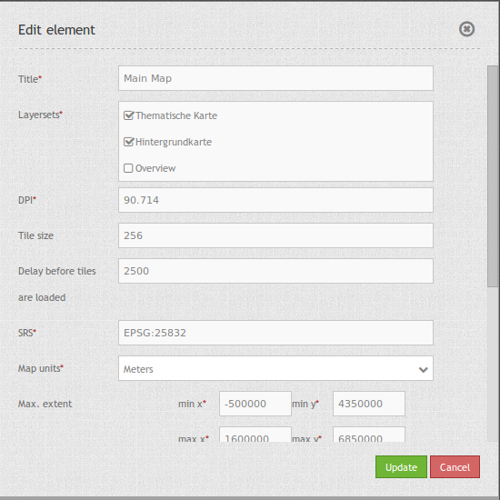
- Title: Title of the element. The title will be listed in “Layouts” and allows to distinguish between different buttons. It will be indicated if “Show label” is activated.
- Layersets: refer to a layerset, define the layerset first and refer to it (propably main map).
- DPI: resolution, default is 72.
- SRS: coordinate reference system. Two ways of srs definitions are supported: EPSG: CODE or EPSG:CODE|MY SRS TITLE.
- Tile size: Size of the tiles of tiled WMS services.
- Delay before tiles: For future use of WMS-T if time parameters are used (actually not applicable).
- Map units: units to use degrees/meters, default is degrees.
- Max. Extent: maximal map extents.
- Start Extent: map extents for the start of the application.
- Scales (csv): a csv scale list.
- Max. resolution: at the moment only auto is supported, so please do not change.
- OL image path: OpenLayers image path, at which the images are saved (bundles/mapbendercore/mapquery/lib/openlayers/img).
- Other SRS: other coordinate reference systems. Two srs definitions are supported: EPSG: CODE or EPSG:CODE|MY SRS TITLE.
YAML-Definition:
layerset: null             # refer to a layerset, define the layerset first and refer to it
dpi: 72                    # resolution, default is 72
srs: "EPSG:4326"           # coordinate reference system. Two ways of srs definitions are supported:
                             - "EPSG:CODE" or
                             - "EPSG:CODE|MY SRS TITLE"
units: "degrees"           # units to use degrees/meters, default is degrees
extents: array(
    max: array(0, 40, 20, 60)    # maximal map extents
    start: array(5, 45, 15, 55)) # map extents for the start of the application
scales: "25000000,10000000,5000000,1000000,500000" # a csv scale list
maxResolution: "auto"      # at the moment only auto is supported, so please do not change
otherSrs: array(
   "EPSG:31466",
   "EPSG:31467",
   "EPSG:25832")           # other coordinate reference systems. Two srs definitions are supported:
                             - ["EPSG:CODE","EPSG:CODE"] or
                             - ["EPSG:CODE|MY SRS TITLE","EPSG:CODE|MY SRS TITLE"]
imgPath: "bundles/mapbendercore/mapquery/lib/openlayers/img"   # path of images
tileSize: 256             # size of tiles
wmsTileDelay: 2500        # delay on WMS-T (actually not applicable)
Controlling by URL-parameters
Make Layer visible
If you have a Layer with the id <layerid> in a service with the id <serviceid> you may pass the URL parameter visiblelayers to turn the layer visible:
?visiblelayers=<serviceid>/<layerid>
You may pass multiple such layers, seperated by comma.
The layerid and serviceid values are specific to an application. You can get the layerid and serviceid in the specific application, namely in the layerset and there in a layer. Each layer has an icon with three small dots on the right side. Click on the icon and a popup window will appear.
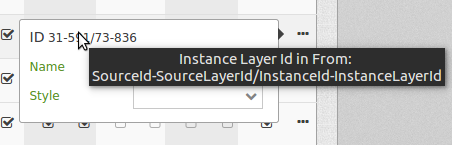
The first value lists the internal SourceID and SourceLayerId (31-591). The seconds value lists the InstanceID and InstanceLayerId, that we want to use now (73-836).
Use this values for the “visibleLayers” parameter in your URL, and seperate them by a slash.
For example: http://localhost/mapbender/application/myapp?visiblelayers=73/836
If you have two layers that are not visible by default, put the two values of layerid and serviceid into the URL and seperate them by a comma.
For example: http://localhost/mapbender/application/myapp?visiblelayers=73/836,73/840
Passing POIs
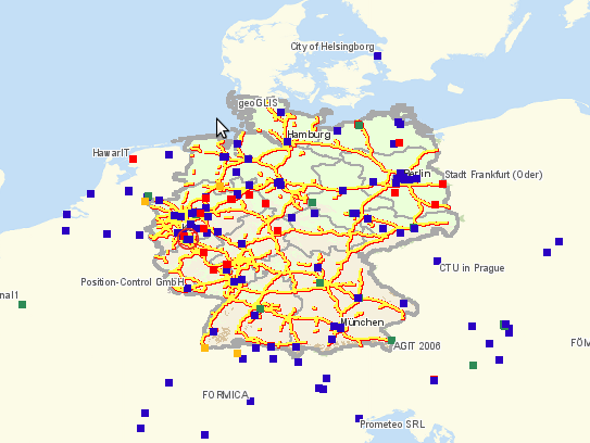
You can pass one or more POIs in the URL. Each POI has the following parameters:
- point: coordinate pair with values separated by comma (mandatory)
- label: Label to display (optional)
- scale: Scale to show POI in (optional, makes only sense with one POI)
If you pass more than one POI, the map will zoom to 150% of the POIs bounding.
To pass a single POI, use the following URL format:
?poi[point]=363374,5621936&poi[label]=Label&poi[scale]=5000
To pass multiple POIs, use the following format:
?poi[0][point]=363374,5621936&poi[0][label]=Label%201&poi[1][point]=366761,5623022&poi[1][label]=Label%202
Passing BBOX
You can pass a BBOX to zoom to by using the following URL query parameter:
?bbox=364286,5622263,365979,5622806
Passing SRS
You can pass a favorite EPSG code you want to use on start of the application by URL query parameter:
?srs=EPSG:4326
Passing CENTER
You can pass a coordinate. The application will open and display the coordinate in the center. In this case, you also have to set the SRS
?center=364286,5622263
more start parameter
The elments WMS Loader and WMC Loader provide also parameter you can user on start. Have a look at the element discription for further information.
Class, Widget & Style
- Class: Mapbender\CoreBundle\Element\Map
- Widget: , mapquery//lib//openlayers//OpenLayers.js, mapquery//lib//jquery//jquery.tmpl.js, mapquery//src//jquery.mapquery.core.js, proj4js//proj4js-compressed.js, mapbender.element.map.js
- Style: mapbender.elements.css, mapquery//lib//openlayers//theme//default//style.css
HTTP Callbacks
None.