Sources
With Sources, you can register:
OGC WMS: Web Map Service
OGC WMTS/TMS: Web Map Tile Service / Tile Map Service
Vector Tiles
OGC API - Features
Further information about the registration process of services and their usage in applications is available in the Quickstart chapter Load sources.
Load sources
Tip
It is important to check the service before it is registered in Mapbender. To do that, open the getCapabilities-Request (see example in Service URL) in your browser.
To register a service, click on  Add source and select a source type.

In the configuration you can set different parameters depending on the type that was selected:
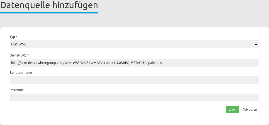
Service URL: URL to the Capabilities document of the service (e.g. OGC WMS Version 1.3.0:)
Username / Password: Input of the username and the password for secured services.
Click on Load to register the service to the repository.
After a successful registration, Mapbender will provide an overview of the service.
Sources Overview
The sources and shared instances sections list and provides information about the services registered:
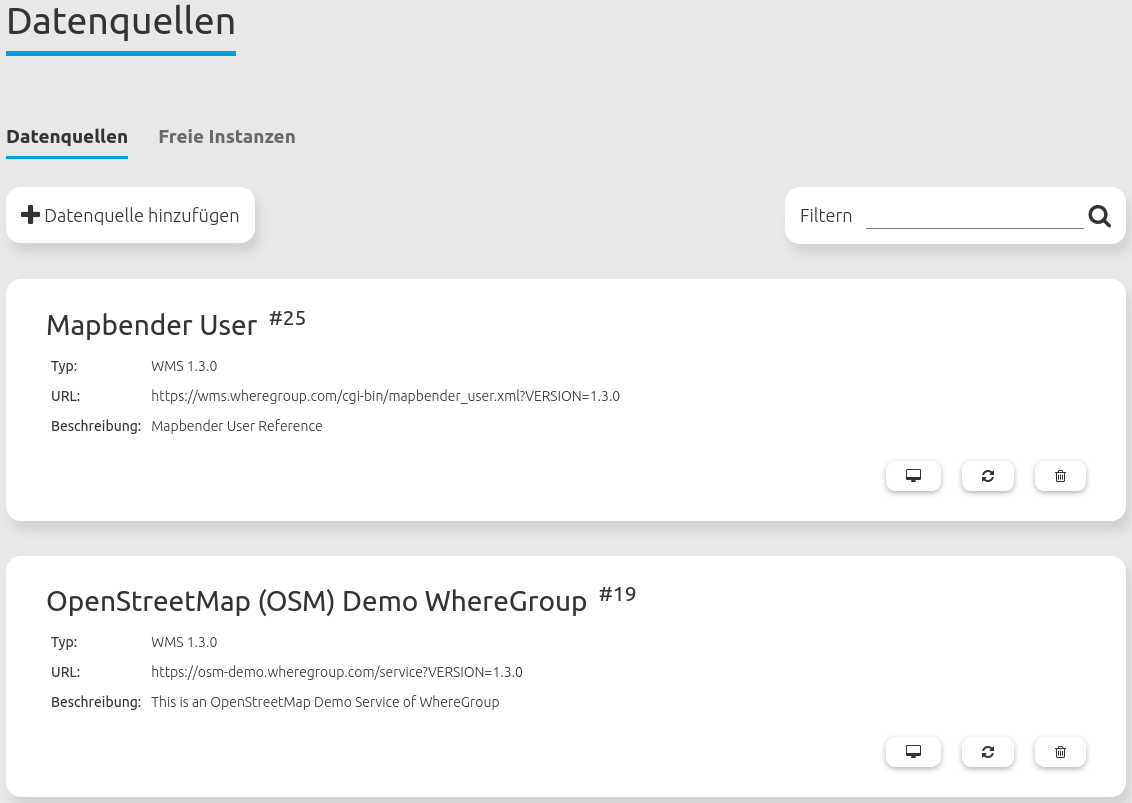
Filter: Search for services names, URLs, types and descriptions.
Show metadata: Shows metadata about a specific service. Opens a new field that lists specific metadata, Mapbender applications that use the source, contact information, details (e.g. service version) and layers.
Update source: Updates service information by reloading the getCapabilities document.
Delete source: Removes the registered service from Mapbender.
Source Information
The data source information provides information about the service.
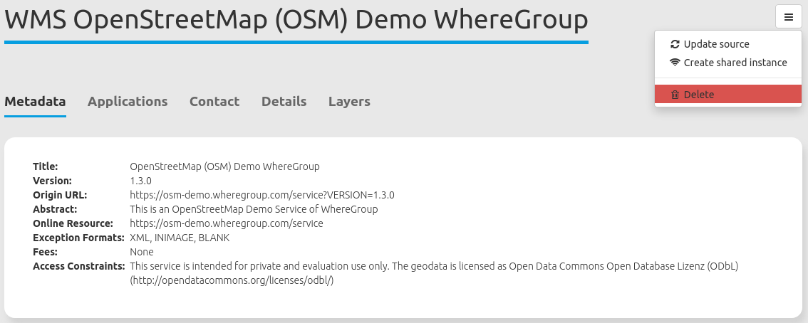
The following information was taken from the job description:
Metadata
Contact
Details
Layers
At the section Applications, you will find an overview of the applications in which the service has been integrated.
Source menu button
In the metadata dialog of a specific source, it is also possible to click on the menu button.
The menu provides the following options:
Update source: Updates service information by reloading the getCapabilities document.
Create shared instance: Creates a new shared instance from the specific service. The instance is listed in the Shared instances tab.
Delete: Removes the registered shared instance from Mapbender.
Updating sources
To update a source in the Backend, you first need to navigate to the Sources Backend list.
On this page, look for the layer you wish to update via scrolling or use the search box.
After you’ve found it, click on its  Refresh button.
You can then update the WMS: If you wish, modify the URL or other settings, such as user name and/or password.
Refresh button.
You can then update the WMS: If you wish, modify the URL or other settings, such as user name and/or password.
Hint
Of course, it is possible to update a source without changing any parameters. The Capabilities document is loaded again.
Moreover, there are two checkboxes handling layer updates:
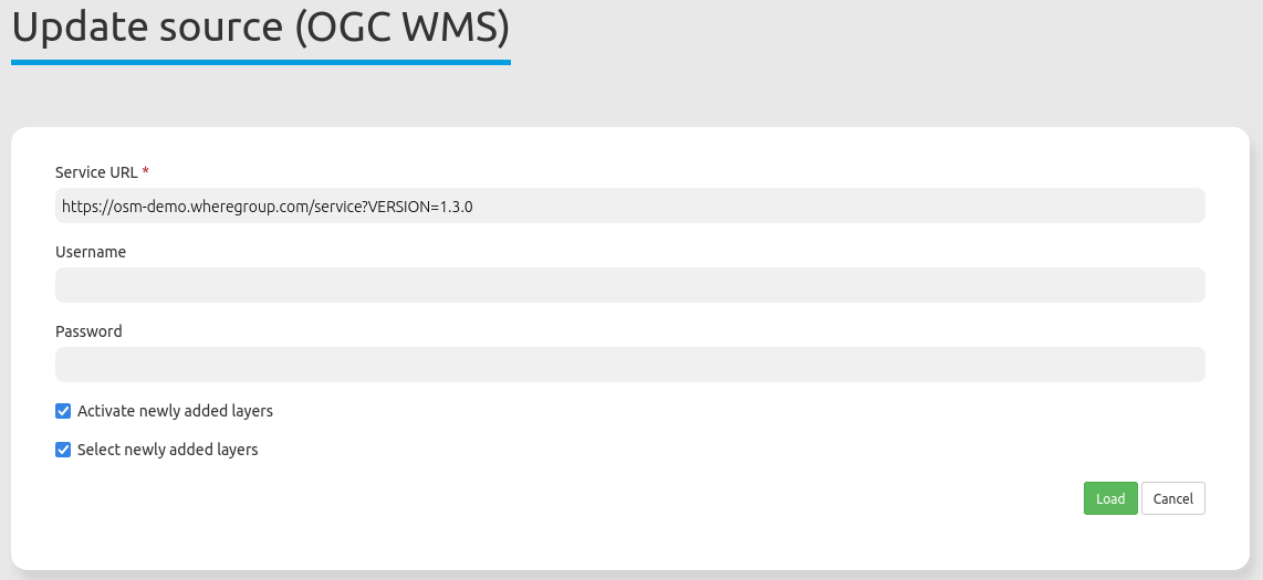
Activate newly added layers: If active, the newly added layers will automatically set active in embedded applications. If the checkbox is not checked, new layers will not appear in the layertree.
Select newly added layers: If active, the newly added layers will automatically be visible and set active in embedded applications. However,
Activate newly added layersmust also be set for this. IfSelect newly added layersis not set, the layer will appear in the layertree but will not be activated.
If you want to save the changes, click the Load button to refresh the WMS. This will re-read the getCapabilities document. The updated version will be displayed in the configuration settings, with changes applied in applications using the service.
Data Source Types
WMS
type: must be wms
title: The source title as displayed in the layer tree
version: WMS version (default: 1.1.1)
url: URL to the service’s Get capabilities XML
format: Mime type for the image format requested (default: image/png)
info_format: Mime type for the feature info format (default: text/html)
proxy: Bool value whether the service should be proxied (default: false)
tiled: Bool value whether the wms data should be requests as tiles (default: false)
layerorder: “standard” or “reverse” (the latter is used mainly for QGIS Server). (default: parameter wms.default_layer_order which again defaults to “standard”)
isBaseSource: boolean value if the source should be treated as a base source
transparent: boolean value whether the TRANSPARENT flag should be set (default: true)
opacity: int 0 (fully transparent)-100 (fully opaque) (default: 100)
visible: initial selected state of the root layer. (default: true)
toggle: initial folder state of the root layer in the layer tree (default: true = folder is expanded)
allowToggle: can the user collapse/expand the root layer? (default: true)
minScale: minimum scale (1:x) where the root layer is displayed (default: unset)
maxScale: maximum scale (1:x) where the root layer is displayed (default: unset)
legendurl: url for the root layer’s legend
layers: optional object to modify individual sublayers. The key is arbitrary, but should be unique. The value is an object with the following settings:
name: The layer’s name, as in the <Name> tag of the layer within the GetCapabilities XML
title: The layer title as displayed in the layer tree
visible: initial selected state of the layer. (default: true)
toggle: initial folder state of the layer in the layer tree (default: false = folder is collapsed)
allowToggle: can the user collapse/expand the layer? (default: true)
minScale: minimum scale (1:x) where this layer is displayed (default: unset)
maxScale: maximum scale (1:x) where this layer is displayed (default: unset)
legendurl: url for this layer’s legend
layers: sublayers, array with the same structure as the layers on the top level
WMTS/TMS
The Web Map Tile Service (WMTS) is a standard geospatial service that enables the provision and retrieval of digital maps in the form of tiles.Tile Map Service (TMS) is a specification for tiled web maps that uses a simple, REST-like URL structure to deliver map data. TMS bridges the gap between the basic OpenStreetMap standard and the complex Web Map Service by providing easily accessible tile URLs and support for different coordinate reference systems.
Loading WMTS/TMS Source
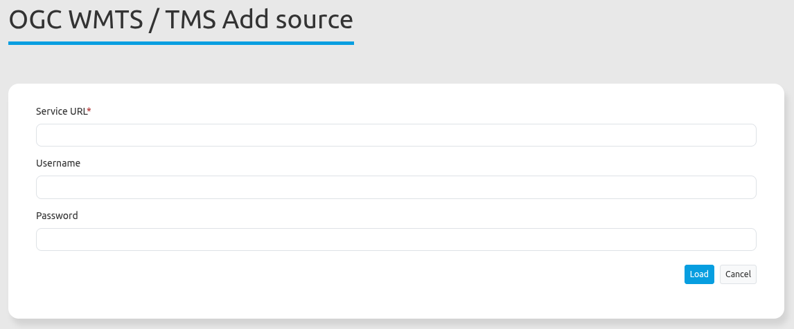
Service URL: URL to the Capabilities document of the service (e.g. OpenStreetMap WMTS https://osm-demo.wheregroup.com/wmts/1.0.0/WMTSCapabilities.xml)
Username / Password: Input of the username and the password for secured services.
YAML
type: must be wmts or tms
url: URL to the service’s Get capability XML. Note that to obtain the TileMatrices this document will be downloaded for every page view (unlike for database WMTS sources, where this information is cached in the database)
title: The source title as displayed in the layer tree
basesource (alias: isBaseSource): boolean value if the source should be treated as a base source
opacity: int 0 (fully transparent)-100 (fully opaque)
selected (alias: visible): initial selected state of the root layer. (default: true)
allowSelected: can the user change state of the root layer in the layertree? If selected and allowSelected are both false, the layer is ignored. (default: true)
toggle: initial folder state of the root layer in the layer tree (default: true = folder is expanded)
allowToggle: can the user collapse/expand the root layer? (default: true)
layers: optional object to modify individual sublayers. The key should be the value of the <ows:Identifier> attribute in the GetCapabilities document (for WMTS) or the url suffix of the layer for TMS. For example, if The URL of the Capability document is https://osm-demo.wheregroup.com/tms/1.0.0/ and the layer’s href in the TileMap tag is defined as https://osm-demo.wheregroup.com/tms/1.0.0/osm/webmercator, the layer key will be osm/webmercator.
title: The layer title as displayed in the layer tree
active: if false, the layer is ignored and won’t be available in the application at all (default: true)
selected (alias: visible): initial selected state of the layer. (default: true)
allowSelected: can the user change state in the layertree? If selected and allowSelected are both false, the layer is ignored, as if active was set to false. (default: true)
Vector Tiles
Vector Tiles are a format for transmitting geographic vector data in tile form, enabling flexible and performant rendering of interactive maps directly in the browser.
Loading Vector Tiles Source
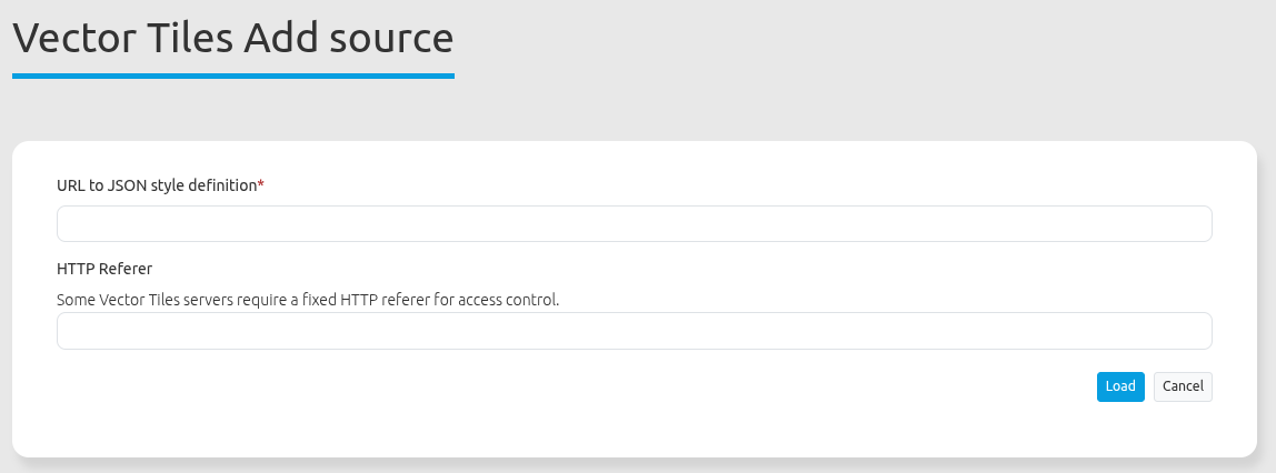
Service URL: URL to the Capabilities document of the service (e.g. bm_web_col https://sgx.geodatenzentrum.de/gdz_basemapde_vektor/styles/bm_web_col.json)
HTTP Referer: Some services require a specific HTTP referer header to accept requests. If the service demands this, please enter the corresponding URL here.
YAML
type: must be vector_tiles
title: The source title as displayed in the layer tree
jsonUrl: URL to the Mapbox Style Spec JSON file
basesource (alias: isBaseSource): boolean value if the source should be treated as a base source
opacity: int 0 (fully transparent)-100 (fully opaque) (default: 100)
selected (alias: visible): initial selected state of the layer. (default: true)
allowSelected: can the user change the selected state? (default: true)
toggle: initial folder state of the root layer in the layer tree (default: true = folder is expanded)
allowToggle: can the user collapse/expand the root layer? (default: true)
minScale: minimum scale (1:x) where the source is displayed (default: unset)
maxScale: maximum scale (1:x) where the source is displayed (default: unset)
featureInfo: is featureinfo enabled by default? (default: true)
featureInfoAllowToggle: can the user toggle the feature info state? (default: true)
featureInfoPropertyMap: If not empty, only the specified properties will be displayed in the feature info. Specify as YAML array. The key is the name of the field, the optional value is the translation. Example:
class
name
layer: Layer-Name
hideIfNoTitle: Hide features with empty title in the featureInfo (default: true)
featureInfoTitle: Property/Properties of the feature that is/are displayed as title above the table. ${property} will be replaced by the property’s value. If not specified, the first non-empty value from “label”, “name”, and “title” will be used.
printScaleCorrection: Resolution correction for printing. Default value is 1.0. Higher values result in more details and smaller labels; lower values in less details and larger labels.
legendEnabled (alias: legend): should a legend be displayed for this source? (default: false)
legendPropertyMap: If not empty, only the specified layers will be shown in the legend. Specify as a YAML array. The key is the layer ID from the “layers” field in the style JSON; the optional value is the translation. Example:
City
Stations
Transport: Public Transport
bbox: Bounding box (array xmin, ymin, xmax, ymax) for the source
OGC API - Features
OGC API - Features is an OGC Standard that offers the capability to create, modify, and query spatial data on the Web. The Standard is the successor of the OGC WFS Standard.
Read more about OGC API - Features at the OGC documentation https://ogcapi.ogc.org/features/.
Loading an OGC API - Features Service
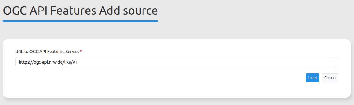
URL to an OGC API - Features Service: Service URL (for example bm_web_col https://sgx.geodatenzentrum.de/gdz_basemapde_vektor/styles/bm_web_col.json oder Daten des Liegenschaftskatasters in NRW https://ogc-api.nrw.de/lika/v1 )
YAML
type: must be ogc_api_features
title: The source title as displayed in the layer tree
jsonUrl: URL to the OGC API Features Service
basesource (alias: isBaseSource): boolean value if the source should be treated as a base source
opacity: int 0 (fully transparent)-100 (fully opaque) (default: 100)
selected (alias: visible): initial selected state of the layer. (default: true)
allowSelected: can the user change the selected state? (default: true)
toggle: initial folder state of the root layer in the layer tree (default: true = folder is expanded)
allowToggle: can the user collapse/expand the root layer? (default: true)
featureLimit: maximum number of features requested from the service (default: 1000)
minScale: minimum scale (1:x) where the source is displayed (default: unset)
maxScale: maximum scale (1:x) where the source is displayed (default: unset)
featureInfoPropertyMap: If not empty, only the specified properties will be displayed in the feature info. Specify as YAML array. The key is the name of the field, the optional value is the translation. Example:
class
name
layer: Layer-Name
Collections
title: The title of the collection as displayed in the layer tree
featureLimit: maximum number of features requested from the service (default: 1000)
minScale: minimum scale (1:x) where this source is displayed (default: unset)
maxScale: maximum scale (1:x) where this source is displayed (default: unset)
visible: initial selected state of the source. (default: true)
toggle: initial folder state of the source in the layertree (default: false = folder is collapsed)
allowToggle: can the user collapse/expand the layer? (default: true)
allowInfo: does the collection provide information (default: false)
info: initial info state of the source (default: false)