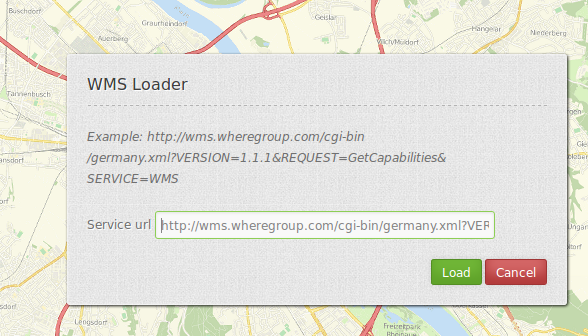
WMS Loader
Opens a dialog in which a WMS can be loaded via the getCapabilities-Request. You can load WMS 1.1.1 and WMS 1.3.0.

Configuration

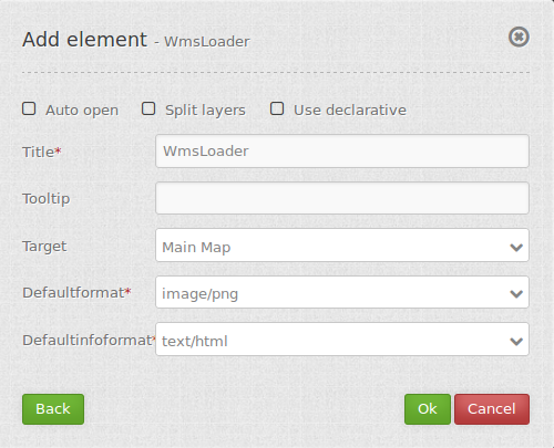
- Auto open: true/false open when application is started, default false.
- Split layers: split layer on load of the service, default false.
- Use declarative: allow to load service from a link (for example from featureInfo or search) and define the layers to activated, default false.
- Title: Title of the element. The title will be listed in “Layouts” and allows to distinguish between different buttons. It will be indicated if “Show label” is activated.
- Tooltip: text to use as tooltip.
- Target: Id of Map element to query.
- Defaultformat: default format is image/png, further possibilities: image/gif, image/jpeg.
- Default infoformat: default infoformat is text/html, further possibilities: text/xml, text/plain.
YAML-Definition:
target: ~                            # Id of Map element to query
tooltip: 'WMS Loader'                # text to use as tooltip
autoOpen: false                      # true/false open when application is started, default false
defaultFormat: 'image/png'           # default format is image/png, further possibilities: image/gif, image/jpeg
defaultInfoFormat: 'text/html'       # default infoformat is text/html, further possibilities: text/xml, text/plain
splitLayers: false                   # split layer on load of the service, default false
useDeclarative: false                # allow to load service from a link (for example from featureInfo or search)
                                     # and define the layers to activated, default false
You need a button to show this element. See button for inherited configuration options.
How to add a WMS by defining a link
You can add a WMS to Mapbender by defining a link f.e. in your WMS featureinfo or your search results.
Activate the option use Declarative in the WMS Loader element (in a YAML application set the option useDeclarative to true).
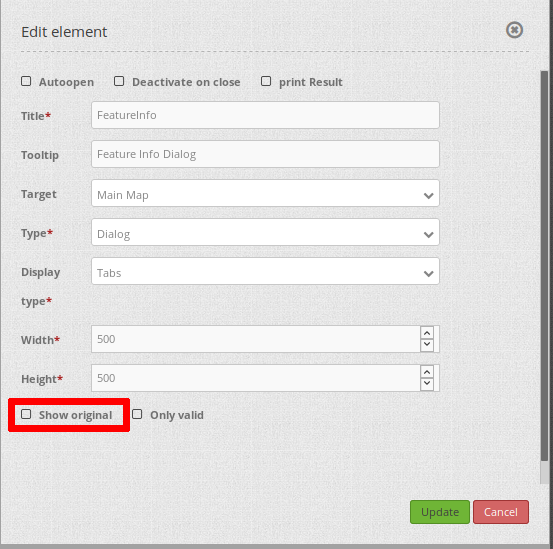
If you wan to use this functionality in a FeatureInfo (for example with a WMS where you have control of), deactive the following parameter in the Feature Info element.
show Original: deactiviated (false). Now the FeatureInfo response is rendered directly via Mapbender instead of an IFrame and the functionality with the following links will work.

The link has to look like this:
<a mb-action="source.add.wms" mb-layer-merge="1" mb-wms-merge="1"
mb-wms-layers="Gewaesser,Fluesse"
href="http://wms.wheregroup.com/cgi-bin/germany.xml?VERSION=1.1.1&REQUEST=GetCapabilities&SERVICE=WMS">load service</a>

<a mb-action="source.add.wms" mb-layer-merge="1" mb-wms-merge="1"
mb-wms-layers="Gewaesser,Fluesse"
mb-url="http://wms.wheregroup.com/cgi-bin/germany.xml?VERSION=1.1.1&REQUEST=GetCapabilities&SERVICE=WMS" href="">load service</a>
mb-action="source.add.wms"    # defines action to add a  WMS
mb-wms-merge="1"              # adds the WMS only once, if WMS is already part of the application it will use the WMS which is there (default is 1)
mb-layer-merge="1"            # default is 1 which means: activate the layers passed mb-wms-layers and do not disable the layers which are already active.
mb-wms-layers="Gewaesser,Fluesse" # defines the layers to be activated, _all activates all layers, default all layers are deactivated
href oder mb-url              # refer to the WMS getcapabilities URL
Class, Widget & Style
- Class: Mapbender\WmsBundle\Element\WmsLoader
- Widget:
- Style:
HTTP Callbacks
None.