Map
The map is the central element of a Mapbender application. It is based on OpenLayers and has be integrated into the Map area of the Backend.
Configuration
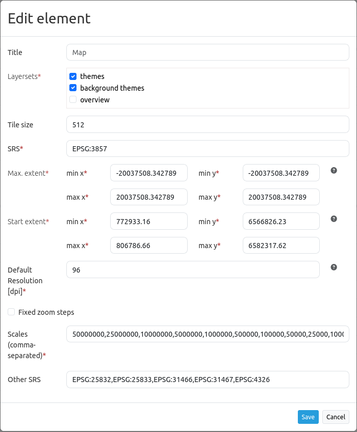
Title: Title of the element. It will be listed in the Layouts section.
Layersets: Select which Layerset will be displayed on the map. Their order is changeable via drag & drop.
Tile size: Size of the tiles of tiled WMS services.
SRS: Spatial reference system. Two ways of SRS definitions are supported: EPSG:CODE or EPSG:CODE|MY SRS TITLE. If you do not enable a custom SRS title, the default title for each SRS from the mb_core_srs table is used.
Max. extent: Maximal map extent, defined by BBOX parameters. This rectangle defines the possible map extent. In response to clicking the globe icon in the Navigation Toolbar, the map view will zoom out to this extent.
Start extent: Map extent that is visible at application launch, defined by BBOX parameters. This rectangle defines the start map extent. In response to clicking the home icon in the Navigation Toolbar, the map view will zoom to this extent.
Default Resolution [dpi]: The default resolution adapts to the screen resolution based on the configured value in dpi. Default: 96 dpi.
Fixed zoom steps: This option activates a zoom behaviour with fixed scales. This is useful to increase visual quality of services that are cached on very particular resolution steps only. When set true, scale denominator snaps to one of the values given in the scales option as defined below (default: false).
Scales (csv): A csv scale list. These scales will be supported in your application if you zoom (e.g. via mouse wheel)
Other SRS: Other spatial reference systems. Two SRS definitions are supported: EPSG:CODE or EPSG:CODE|MY SRS TITLE.
Configuration example
The map element has to be included into the Map area:

The map can entail all instances that are defined in the layerset. The following example distinguishes between a main (1) and overview (2) layerset.
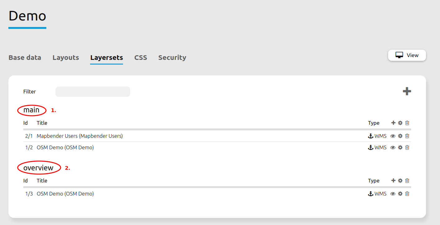
In order to display all Layersets on the map, they have to be activated. Multiple selections are possible as well. De-selected layersets can function as an Overview. In the example, main is displayed on the main map and overview as an overview map.
The field SRS defines the coordinate reference system that is used at application start. In this example, the coordinate reference system EPSG:3857 or WGS 84/Pseudo-Mercator was chosen. If the application should support other coordinate systems, simply add those in the Other SRS field. In this example, the following codes are used: EPSG:25832 (ETRS89/UTM Zone 32N), EPSG:25833 (ETRS89/UTM Zone 33N), EPSG:31466 (DHDN/3-degree Gauss-Krüger Zone 2), EPSG:31467 (DHDN/3-degree Gauss-Krüger Zone 3) and EPSG:4326 (WGS 84).
The field max. Extent states the maximum zoomable extent of the map application. If there is data outside of the extent, it will not appear in the map. The field start Extent refers to the extent of the map that is visible when the application is started in the browser (in this example: the city of Bonn).
The Default resolution in dpi defines the resolution of the device being used; the corresponding default value of 96 dpi can be adjusted through this field. If the displayed resolution of the map does not match that of the WMS service, changing this value can help to align the map accordingly.
Note
The scale-dependent resolution currently only works reliably on desktops with regular resolution.
Furthermore, the field scales (csv) defines the scales that are usable in the application. It is possible to switch between the defined scales with Scale Selector or Navigation Toolbar. Fixed zoom steps were deactivated in the example. That means it is possible to display undefined zoom levels via mouse scrolling.
YAML-Definition
This template can be used to include the map into a YAML application.
layerset: null             # refer to a layerset, define the layerset first and refer to it
srs: "EPSG:4326"           # coordinate reference system. Two ways of srs definitions are supported:
                             - "EPSG:CODE" or
                             - "EPSG:CODE|MY SRS TITLE"
extents:
    max: [0, 40, 20, 60]    # maximal map extents
    start: [5, 45, 15, 55]  # map extents for the start of the application
scales: "25000000,10000000,5000000,1000000,500000" # a csv scale list
otherSrs:
    - EPSG:31466
    - EPSG:31467
    - EPSG:25832          # other coordinate reference systems. Two srs definitions are supported:
                             - ["EPSG:CODE","EPSG:CODE"] or
                             - ["EPSG:CODE|MY SRS TITLE","EPSG:CODE|MY SRS TITLE"]
tileSize: 256             # size of tiles
Controlling URL parameters
Activating Layers
Mapbender enables the option of activating layers when an application is started via visiblelayers. Activation is possible either via ID or Name.
ID: <InstanceID>/<InstanceLayerID>
Name: <RootLayerName>/<LayerName>
InstanceID/InstanceLayerID: This allows a transmission of the application-specific values of InstanceID and InstanceLayerID:
?visiblelayers=<InstanceID>/<InstanceLayerID>
RootLayerName/LayerName: This allows layers along the combination of RootLayer- and LayerName to be transferred as parameters:
?visiblelayers=<RootLayerName>/<LayerName>
Hint
Please note that the IDs change after every refresh of the service. Passing the name may therefore be the more constant solution.
To display the layer properties, there is an icon with three dots next to each layer in the layerset tab of an application. Click on the icon to open a info window:
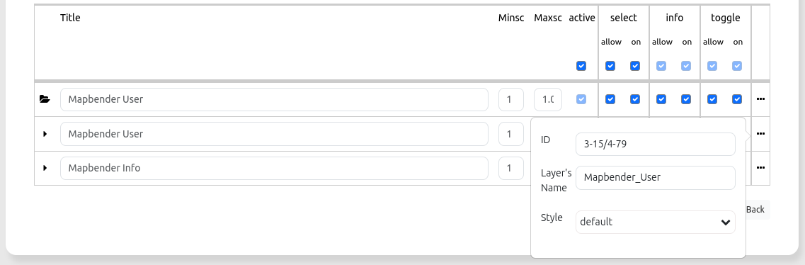
ID: The first value in the upper text field is the internal SourceID and the SourceLayerID (3-15). The second value in the upper text field is the InstanceID and the InstanceLayerID (4-79).
Layer’s Name: The second text field contains the LayerName. The output of the first line will instead pass the RootLayerName.
Style: Styling alternatives can be selected in the third drop-down field (if available).
For an Instance(Layer)ID transfer, use the second value combination after the slash for the visiblelayers parameter in the URL.
Separate the two associated values with a slash (instead of a hyphen):
For example: https://localhost/mapbender/application/myapp?visiblelayers=4/79
Separate two or more non-visible layers by commas. To do this, insert the respective values according to the same scheme:
For example: https://localhost/mapbender/application/myapp?visiblelayers=4/79,1/42
Combinations of names and ID values are also possible:
https://localhost/mapbender/application/myapp?visiblelayers=Mapbender/Mapbender_Names,Mapbender/Mapbender_User,39/149
Passing POIs
You can pass coordinates with the URL. The linked position will be marked on the map using a POI (which can optionally be labelled).
point: coordinates as comma-separated values (mandatory),
label: Label to display (optional),
scale: Scale to show POI in (optional).
To pass a POI, use the following URL format:
?poi[point]=368777,5619411&poi[label]=Rheinaue&poi[scale]=10000
Passing BBOX
You can pass a BBOX to zoom to by using the following URL query parameter:
?bbox=364286,5622263,365979,5622806
Passing the scale
You can set the scale from the list of available scales.
?scale=1000
Passing SRS
You can pass a favorite EPSG code you want to use on start of the application by URL query parameter:
?srs=EPSG:4326
Passing a centered Coordinate
You can pass a coordinate. The application will open and display the coordinate in the center.
?center=364286,5622263
More Start Parameters
The elements WMS Loader and WMC Loader also provide parameters you can use on start. Have a look at the element descriptions for further information.